
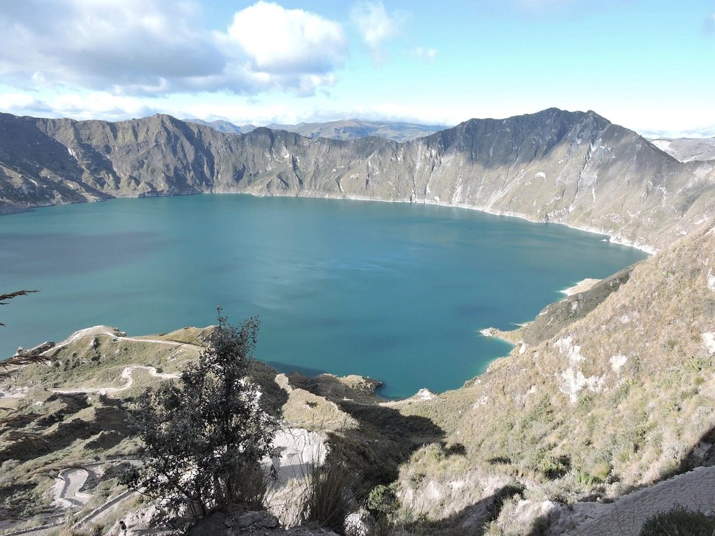
If you have ten days rather than a month, and you want the Andes without a permit lottery or a week of acclimatisation, Ecuador is the country we would send you to. Quito sits at 2,850 m, so you begin acclimatising the moment you land; the volcanoes are lined up along a single valley south of the city; the buses are cheap and frequent; and two classic outings – the village-to-village Quilotoa loop and the walk up to the refuge on Cotopaxi – fit into a week with days to spare. This is the trip we describe to people who have hiked in the Alps or the Rockies and want to know whether the high Andes are for them.
Why Ecuador works as a first trip
The country is small, its highlands are compact, and everything worth walking lies within four hours of Quito. It uses the US dollar, so there is no currency to learn. Because it sits on the equator there are no seasons in the temperate sense, only drier and wetter periods; the best odds of clear summits are from June to September and in a shorter window over December and early January. Most of all, the altitude is gradual. You sleep at 2,850 m in Quito, 2,760 m in Latacunga and around 3,200 m on the loop, and you day-walk to 3,900 m at Quilotoa and 4,800 m on Cotopaxi without ever camping high. That is a gentle way to learn how your body handles thin air.
Getting into position
Quito’s airport lies 40 km east of the city near Tababela, about an hour by road. Give yourself two nights in the capital: the old town is worth a day, and a warm-up walk to Rucu Pichincha (4,696 m), reached from the cable car that climbs out of the city to 3,945 m, is the best acclimatisation hike in the country, about three hours up and two down with a short scramble at the top. From Quito, buses leave every few minutes for Latacunga, 90 km south and about two hours, the base town for both Quilotoa and Cotopaxi. Latacunga is not beautiful, but it is useful: luggage storage, cheap hostels, and local buses to the villages of the loop.
The Quilotoa loop, village by village
Quilotoa is a water-filled caldera about 3 km across, whose rim stands at 3,900 m and whose green lake lies almost 300 m below. The “loop” is a three-day walk between indigenous Kichwa villages on the plateau to the north of it, along farm tracks, footpaths and cobbled lanes, sleeping in family-run hostels that include dinner and breakfast. Nobody carries a tent. The classic direction is to take a bus from Latacunga to Sigchos and walk south toward the crater, so that the biggest climb comes last and the scenery builds.
Day one, Sigchos to Isinlivi, is about 12 km with 400 m of ascent and a long descent to the village at 2,900 m, four hours at an easy pace through pasture and eucalyptus. Day two, Isinlivi to Chugchilan, is also about 12 km but drops to the Toachi river and climbs steeply out of the canyon to 3,200 m, five hours with a lunch stop by the river. Day three, Chugchilan to Quilotoa, is the hard one: 12 km, close to 1,000 m of climbing in stages, first down into another canyon and then up through the village of Guayama to the crater rim, six or seven hours. You arrive at the lip of the caldera with no warning, and the view is worth every step.
The rim itself is a walk of about 10 km that circles the lake in four to five hours, with several short, steep sections of loose sand, and the path down to the water takes 30 minutes; coming back up takes over an hour and there are mules for hire if you regret it. Buses from Quilotoa village return to Latacunga in about two hours. Navigation on the loop is by hand-drawn maps from the hostels plus a downloaded GPS track; the paths are unsigned in places, dogs are numerous and mostly noisy rather than dangerous, and the afternoons cloud over, so walk in the mornings.
Cotopaxi: the refuge walk and beyond
Cotopaxi is a near-perfect glaciated cone of 5,897 m, and its national park begins less than an hour from Latacunga. Most visitors come for a day, by hired 4×4 or with a driver arranged in town, and the standard outing is in two parts. First, the flat and easy circuit of Laguna Limpiopungo at 3,800 m, a wetland with Andean gulls and, on a clear day, the volcano filling the sky. Second, the drive up the volcanic sand road to the car park at about 4,600 m and the walk to the mountain refuge at 4,864 m, 45 minutes to an hour of steep, loose scree that feels like far more. From the refuge a path continues another 150 m up to the edge of the glacier at around 5,000 m, which for many people is the highest they will ever stand. Wind and sudden cold are the norm; carry a warm hat, gloves and a shell even if the car park is sunny.
The summit is a different proposition: a night in the refuge, a midnight start, six to eight hours on crevassed glacier with crampons, rope and ice axe, and by park regulation a certified guide. It is one of the more accessible summits of its height anywhere, but it is not a walk. A better second objective for a first trip is Ruminahui, a rocky 4,721 m peak on the far side of Limpiopungo whose central summit is reached by a good path with a short scramble in five or six hours return. The park has rules that change: registration at the gate, and restrictions on which zones are open depending on the volcano’s activity. Check before you go.
Sequencing the week
- Days 1-2: Quito, with the walk to Rucu Pichincha on the second day.
- Day 3: bus to Latacunga, onward to Sigchos, and a night in Isinlivi.
- Days 4-5: Chugchilan, then the climb to Quilotoa and a night on the rim.
- Day 6: rim walk in the morning, bus back to Latacunga.
- Day 7: Cotopaxi – Limpiopungo, the refuge and the glacier edge.
- Day 8: Ruminahui or a rest day, then back to Quito.
In eight days you will have slept at 3,200 m, walked to 5,000 m, crossed two canyons on foot and stood on the rim of one of the finest crater lakes in the Andes. If at the end of it you find yourself looking south along the valley toward Chimborazo, 6,263 m and the farthest point from the centre of the earth, you will know the answer to the question you came with.