
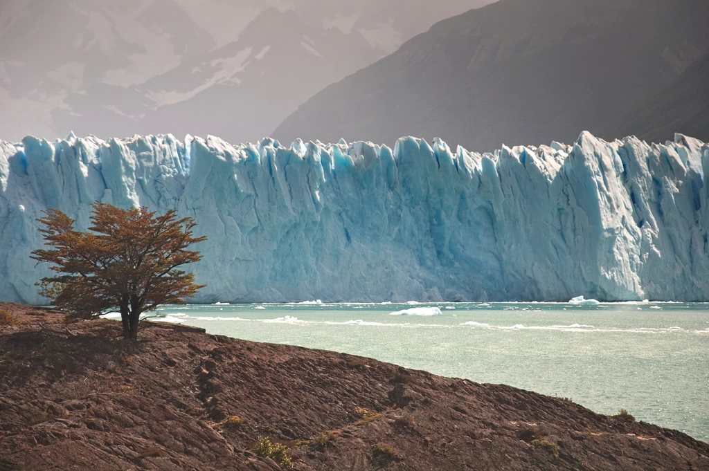
Perito Moreno is the glacier that most people in the world have seen a photograph of, usually at the moment a slab of ice the size of a building drops into the lake. It is 80 km from El Calafate, it has kilometres of walkways facing its front, and on a good day you can stand there for hours watching it collapse. What the photographs do not show is where the ice comes from. Behind Perito Moreno lies the Southern Patagonian Ice Field, one of the largest bodies of ice outside the polar regions, and understanding it changes how you look at every glacier in Patagonia, from Grey in Torres del Paine to the tongues below Fitz Roy.
An ice field, not a glacier
The Southern Patagonian Ice Field is a plateau of ice about 350 km long from north to south and covering roughly 12,000 to 13,000 square kilometres, shared between Chile and Argentina along a border that is still not fully agreed. It sits on the crest of the Andes between about 48 and 52 degrees south, at elevations of 1,000 to 2,000 m, with a few rock peaks poking through. It is the remnant of the much larger ice sheet that covered Patagonia during the last ice age, and it survives today for one simple reason: the westerly winds. Moist air from the Pacific is forced up the Chilean side of the Andes, where annual precipitation on the ice field can exceed 5 m, most of it falling as snow. That snow compacts into ice and flows outward in every direction.
Around fifty large outlet glaciers drain the plateau. On the Chilean side they mostly end in fjords of the Pacific; on the Argentine side they end in the big lakes, Argentino and Viedma, which is why so many of the famous glaciers are in Los Glaciares National Park. Viedma and Upsala are the largest in Argentina, each several hundred square kilometres; Perito Moreno, at about 250 square kilometres and 30 km long, is not the biggest, just the easiest to reach and the most spectacular at its front.
Why Perito Moreno calves so dramatically
The glacier flows down a valley into Lago Argentino and ends against a peninsula of rock called Magallanes. Its front is about 5 km wide and stands 60 to 70 m above the water, with much more ice below the surface. Because the peninsula is directly in its path, the ice is under compression and the face stays steep and active, so calving is constant. On the walkways you hear the crack before you see the fall, then a wave spreads across the Canal de los Tempanos.
Every few years the glacier does something rarer. It advances far enough to touch the peninsula and cut the southern arm of the lake, the Brazo Rico, off from the main body. Water builds up behind the ice dam, sometimes rising 20 m or more, until pressure carves a tunnel through the ice. The tunnel grows into an arch, and eventually the arch collapses in a rupture that can last hours and draws crowds to the walkways. Ruptures have been recorded at irregular intervals through the twentieth century and several times since 2004, with the most recent in 2018. Nobody can predict the next one; the glacier decides.
Is Perito Moreno growing or shrinking
For decades it was called the glacier that defies climate change, because while most of the ice field’s outlets have been retreating, Perito Moreno stayed roughly in balance, advancing in winter and calving back in summer. The truth is more subtle. Its stability has less to do with immunity and more to do with geometry: a high, steep accumulation zone that feeds the tongue quickly, and a front that rests on a shallow sill of rock rather than in deep water. Measurements over the past few years have shown some thinning and slight retreat of the front, and researchers now treat it as a late responder rather than an exception. Upsala, by contrast, has retreated several kilometres since the 1980s, and the ice field as a whole is among the fastest-thinning ice masses on earth for its size.
Visiting the glacier
The glacier sits inside the southern sector of Los Glaciares National Park, which was declared a World Heritage site in 1981. Access is by road from El Calafate, about 80 km, on scheduled buses or by hired car; the last stretch runs along the shore of Lago Argentino with the ice appearing suddenly around a bend. There is a park entry fee paid at the gate. From the car park a network of raised walkways, more than 4 km in total, descends the peninsula in tiers with viewpoints at different heights, and the whole circuit takes two to three hours at a slow pace. Boat trips run along the north and south faces from nearby jetties, giving a different sense of scale.
- Best light is in the morning on the north face and in the afternoon on the south face; overcast days bring out the blue in the ice.
- The busiest hours are 11:00 to 15:00 when the bus tours arrive; going early or staying late gives quieter walkways.
- Bring a warm layer and a shell even in January; the wind off the ice drops the temperature by several degrees.
- Guided walks on the ice itself run from the southern shore during the season and use crampons on the lower glacier; they are booked in advance and have age limits.
The ice field from the trails
Once you know what you are looking at, the ice field appears everywhere in southern Patagonia. Glacier Grey, seen from John Gardner Pass on the Torres del Paine circuit, is an outlet of the same plateau. The glaciers below Fitz Roy and Cerro Torre are small tongues on its eastern edge. The Viedma glacier, visible from the road to El Chalten across the lake of the same name, is one of the largest outlets and has retreated visibly within living memory.
A few crossings of the ice field itself are made every year by expedition parties on skis, taking two to three weeks in autonomy, and the plateau has been traversed end to end. That is beyond the scope of a trekking magazine, but knowing that the white line on the horizon from a Patagonian summit is a continuous sheet of ice hundreds of kilometres long gives the landscape its true scale.
Why it matters for trekkers
The ice field is the reason the weather in Patagonia is what it is, why the wind never stops and why the mountains on its eastern edge are so sharp. The moisture that feeds it is the same moisture that hides Cerro Torre for weeks and floods the trails on the back side of the Paine massif. Stand on the walkways at Perito Moreno, watch the ice fall, and you are watching the end of a process that started as snow on the plateau centuries ago.