
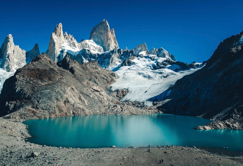
El Chalten is a village of a few thousand people at the end of a paved road in Argentine Patagonia, and its main street points straight at one of the most recognisable mountains on earth. Fitz Roy rises to 3,405 m less than 20 km from the last house, and because the town sits inside the northern sector of Los Glaciares National Park, the trails start on the pavement. No shuttle, no permit queue, no catamaran. You walk out of your door, and by lunch you can be sitting beside a lake at the foot of the granite. This is our guide to the Laguna de los Tres hike and the other day walks on the Fitz Roy side of town.
The mountain and the village
Fitz Roy is not the highest peak in Patagonia, but its sheer granite faces and the constant cloud cap have made it a symbol of the region. The massif is a cluster of spires above a glacier basin: Poincenot to the south, Mermoz and Guillaumet to the north, and the main summit in the middle. El Chalten was founded in 1985, sits at about 400 m, and is reached from El Calafate by 220 km of road in roughly three hours. It has a full range of accommodation, a few shops for supplies and a mountaineering culture that sets the tone; conversation in the bakery in the morning is about the wind forecast.
The park visitor centre at the southern entrance to town is worth ten minutes. Rangers give a short briefing on trail conditions and register hikers who intend to camp, and the free campsites inside the park operate under simple rules: no fires, no cooking outside the designated areas, carry out everything.
Laguna de los Tres: the classic
The trail to Laguna de los Tres is the reason most people come. It starts at the northern end of the village and climbs steadily through lenga forest with the Rio de las Vueltas below. After about 4 km a short spur leads to Laguna Capri, a good first stop with the peaks reflected in still water on a calm morning. The main trail continues on gentle ground across a plateau of bog and forest, with the mountain growing in front of you, until Poincenot campsite at about 8 km. A footbridge crosses the Rio Blanco, and then the last kilometre climbs about 400 m on rock steps and loose stone. It is steep and exposed to wind, and it takes most people an hour.
The reward is the lake itself, at about 1,170 m, an intense blue-green tarn beneath the east face of the massif, with the summit less than 3 km away. Walk a few minutes to the left along the moraine ridge for a second lake, Laguna Sucia, milky and far below, fed by the hanging glaciers of Poincenot. Total distance is 20 to 24 km round trip, with about 800 m of climbing, and eight to ten hours on foot is a realistic day for a reasonably fit walker.
A quieter way in: the northern trailhead
There is a second start on the road to Lago del Desierto, about 17 km north of town on gravel, where a trail follows the Rio Blanco upstream past the Piedras Blancas glacier viewpoint to join the main route at Poincenot. Many locals prefer to begin here, do the climb to the lake, then descend all the way to the village via Laguna Capri. It saves nothing in distance but gives a one-way walk with two different landscapes and a first view of Fitz Roy from the north. Transfers to the trailhead leave early in the morning from the village; check the return option if you plan to walk back the same way.
The other Fitz Roy day walks
- Laguna Capri alone: 8 km round trip, 2.5 to 3 hours, the best short walk for a first afternoon or a cloudy day.
- Mirador Fitz Roy: about 4 km from town at the first viewpoint on the Laguna de los Tres trail, gentle and popular at sunset.
- Chorrillo del Salto: a 20 m waterfall about 4 km north of the village on an almost flat path, ideal for tired legs.
- Loma del Pliegue Tumbado: 19 km round trip and 1,100 m of ascent to a 1,500 m summit south of town, with a panorama of both Fitz Roy and Cerro Torre; the finest viewpoint in the area when the sky is clear.
- The Madre e Hija connector: an 11 km link between the Laguna de los Tres and Laguna Torre trails past two quiet lakes, which lets you combine both classics in one long day or a two-night loop.
Camping under the mountain
Poincenot campsite sits in the forest by the Rio Blanco, one hour below the lake, and it is free. Sleeping there turns the crux of the walk into a sunrise outing: leave the tent at 05:00, climb the 400 m in the dark and watch the east face of Fitz Roy turn pink and then gold as the sun clears the steppe. The morning light lasts a few minutes and is the reason the campsite is full in January. There is no shop and no shelter apart from a small cooking area, water comes from the river, and the wind at night can be brutal, so the tent needs to be pitched with care among the trees. The same is true of De Agostini campsite on the Cerro Torre side, and both are used by people walking the two-day loop through Laguna Madre e Hija.
Weather, season and the wind forecast
The hiking season runs from October to April, with December to February the busiest and the longest days. The mountain makes its own weather, and a clear forecast is the only thing that matters. Fitz Roy is often hidden for days at a time, and the local habit of watching the wind and cloud forecasts each evening and moving plans accordingly is worth adopting. If the sky clears at 15:00, go up then and be prepared to descend at dusk; if the wind is above 60 km/h, the last kilometre to the lake becomes dangerous and rangers may close it.
Bring the same layering as anywhere in Patagonia: shell jacket, warm mid-layer, hat and gloves even in summer. Water from the streams is drinkable. Trail markers are clear and the paths are heavily used, so navigation is easy; the difficulty is purely the weather and the final climb. Give the mountain more than one day if you can. The people who see Fitz Roy at its best are the ones who stayed long enough to be there when the cloud lifted.