
The ascent is short but steep, access is controlled by a separate ticket, and the details of that ticket decide whether you get a place at all. This guide explains why the system is built the way it is, then walks through the climb itself.
- You need a dedicated ticket that bundles a citadel circuit with the mountain, and it sells out far ahead of the date.
- The trail is a steady incline of stone steps with cables on the exposed sections, and it suits people who are comfortable with heights.
- Dry months give firmer footing and clearer views, while wet months make the steps slick.
What exactly is Huayna Picchu, and where does it sit?
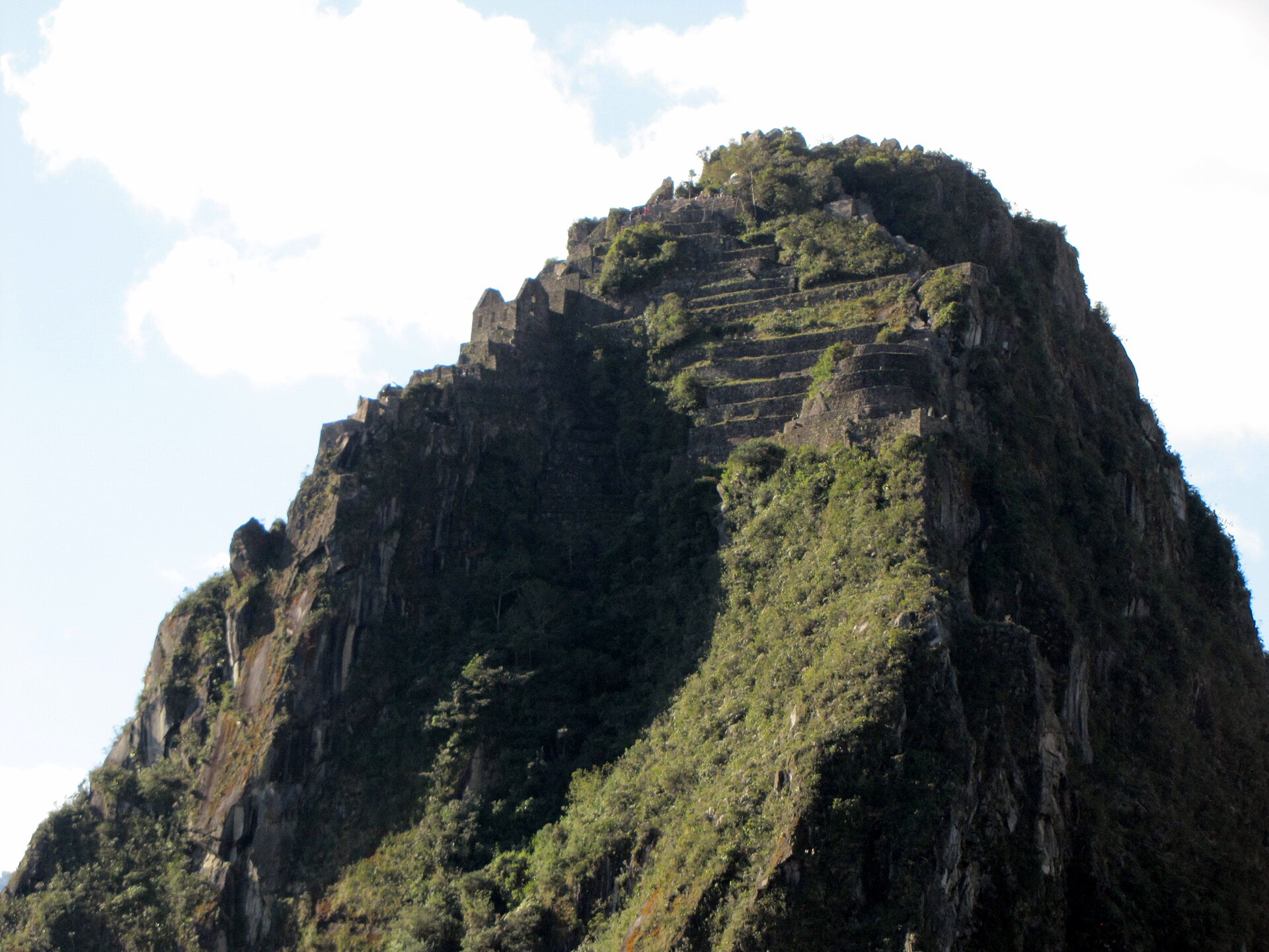
Huayna Picchu rises just north of the Machu Picchu citadel, inside the district of Machupicchu in Urubamba province, in the Cusco region. The Urubamba River curls almost completely around its base, which is why the mountain looks so isolated from the surrounding ridges.
The name comes from Quechua. Wayna means young and picchu means peak, so the name translates as the young mountain. It is a deliberate pairing with Machu Picchu Mountain, the old mountain, on the opposite side of the ruins. You will see both Huayna and Wayna on signs and in guidebooks. They refer to the same summit, and the spelling difference exists because Quechua was not historically written in a fixed alphabet.
The summit stands at 2,693 m (8,835 ft). The citadel itself sits lower, at 2,430 m (7,972 ft), so the climb gains roughly 260 m from the ruins. That is a modest figure on paper, and the reason the hike feels harder than the number suggests is that all of it is packed into a short, steep path.
Why do you need a separate ticket, and how do you get one?
The mountain is part of the Machu Picchu circuit system, so you cannot simply walk to it with a standard entry ticket. The ticket that includes Huayna Picchu is a combined one: it pairs a specific circuit of the citadel with access to the mountain. You do not get to choose the circuit independently. Whatever circuit is printed on your ticket is the one you follow.
The point of the arrangement is protection and safety. The path is narrow, the steps are old, and the summit is small, so the authorities cap how many people can be on the mountain at once. That cap is the whole reason the ticket is hard to get.
A few practical points follow from that:
- Buy through the official government ticketing channel or an authorised operator, and do it as early as you can. Sources describe booking at least several months ahead, with the busiest season needing the longest lead time.
- Entry is split into time groups. The morning group goes in during the early hours and the later group around mid-morning, and you must start the hike within the window printed on your ticket.
- Your passport and ticket are checked at the mountain checkpoint, and the name on the ticket must match your ID.
- If you want more than one hike in a day, each one needs its own ticket.
Because published figures for daily capacity differ from one operator to another, treat any single number with caution and rely on what the ticketing platform shows for your date.
What does the climb actually involve?
The trailhead is near the Sacred Rock inside the citadel, where you sign in at the checkpoint. From there the route is easy to follow, and you are not likely to lose the path. What makes it demanding is the constant gradient, the height of certain steps, and the exposed edges.
The lower section
The first stretch is a zigzag trail through vegetation. It is the gentlest part, and the useful move here is to settle into a pace you can hold, because the steepest ground comes next.
The stone stairs
Higher up, the trail turns into a long run of original Inca steps, some narrow and some tall, with steel cables on the most exposed parts. The famous name for this section, the Stairs of Death, describes the steepness and the drop on one side. It is not a record of frequent accidents. The sensible approach is to take one step at a time, hold the cable, and use your hands when a step is high. Sources describe angles of around 60 degrees on the steepest flights.
The summit passage
Near the top, the path squeezes through a narrow natural gap between rocks. Many people pass through it on the descent, and it is tight enough that you may need to crouch. A backpack can snag here, so be ready to take it off and push it ahead of you.
At the summit there is little flat space, just large boulders, so it helps to be patient about sharing the room for photographs. The view looks straight down onto the plaza, terraces and agricultural sectors of the citadel, with the river curving below.
How long does it take, and how hard is it really?
Allow around two to three hours for the whole hike, counting the ascent, time at the top and the descent to the checkpoint. Operators quote slightly different durations, which reflects different walking speeds more than different routes, so plan for the longer end and treat the shorter end as a bonus.
On difficulty, the honest description is moderate to demanding. The effort comes from sustained uphill walking and from the exposure, not from technical climbing. If you walk regularly and heights do not bother you, you can do it at your own rhythm.
It is a poor choice for some people, and it is better to know that before booking:
- Anyone with vertigo or a strong fear of heights.
- People with bad knees or difficulty on tall, uneven steps.
- Young children. The minimum age requirement can change, so check the current rule on the official ticketing platform before you buy.
The descent deserves as much attention as the ascent. Tired legs on tall, steep steps are where most slips happen, so keep three points of contact where you can, turn sideways if that feels steadier, and give people coming the other way a clear call before you pass on a narrow section.
How does altitude affect the effort, and when should you go?
At 2,693 m the summit is not extreme by Andean standards, and altitude sickness is less of a concern here than in Cusco, which sits much higher at 3,399 m (11,152 ft).
The caution applies to anyone flying in from the coast and heading straight to the mountain. Give yourself a couple of days in Cusco or the Sacred Valley first, so your body is not meeting both a big altitude change and a steep climb on the same day.
On timing, the logic is about footing and visibility rather than comfort:
- The drier months, roughly May to October, bring clearer skies and firmer steps.
- The rainy months, roughly November to April, make the stone slippery and can hide the views in cloud. A wet staircase beside a drop is the single biggest avoidable risk on this hike.
- An early start helps in every season, because it means cooler air, fewer people on the narrow sections and better light.
If the forecast for your booked day is poor, take the slippery steps seriously and be willing to slow down or skip the summit rather than force it.
What should you carry, and how do you combine it with the citadel?
This is a half-day outing, so the pack should be small and light. A heavy bag is a nuisance in the summit passage and on tall steps.
- Sturdy shoes with good grip, because the stone is worn and can be damp.
- Water, since there is no reliable place to refill once you are on the mountain.
- Sun protection and insect repellent, as the cloud-forest setting has both strong sun and biting insects.
- A light rain layer for the wet months, and your passport and printed or saved ticket for the checkpoint.
For the day itself, think in terms of your ticket windows. You enter the citadel at one time and begin the mountain within a set window afterwards, so build the rest of the visit around those two fixed points. A common pattern is to do the mountain first while energy is high, then spend the remaining time walking the citadel circuit printed on your ticket. Keep in mind that your circuit is fixed by the ticket, so look at which parts of the ruins it covers before you plan where to linger.
Lastly, allow a margin for the descent and the sign-out at the checkpoint. Rushing the steps to catch a later slot is the wrong trade, and a relaxed return is worth more than the extra minutes.
Frequently asked questions
Is Huayna Picchu the same as Wayna Picchu?
Yes, they are two spellings of the same mountain. Quechua was not historically written in a fixed alphabet, so both forms appear on signs and in guidebooks.
Do you need a guide to climb Huayna Picchu?
Sources disagree on whether the mountain itself needs a guide, and the rules for the wider citadel can differ from the mountain trail. Check the current regulations on the official ticketing platform for your date before you travel.
Is the climb dangerous?
The steepest steps have cables and the main risk is a slip, especially when the stone is wet. Take each step slowly, hold the cable, and avoid the climb in heavy rain if you can.
Can you do Huayna Picchu and another Machu Picchu hike on the same day?
Each hike requires its own ticket, so a second hike means a second booking. Availability is limited, so check both dates and time slots carefully before you commit.
Related reading
- Ausangate Circuit and the Rainbow Mountain Question: Five Days Above 4,500 m
- The Huayhuash Circuit: Ten Days Above 4,000 m in Peru’s Fiercest Range
Sources
- Discover Huayna Picchu Mountain: A 2-Hour Hike Adventure (actionperutreks.com, accessed 2026-11-02)
- Huayna Picchu: Tickets, Hike & Travel Guide (machutravelperu.com, accessed 2026-11-02)
- Huayna Picchu Mountain: Height, Trail, and How to Climb It … (cuscoperu.com, accessed 2026-11-02)
- Full Guide to Hiking Huayna Picchu: Machu Picchu’s Best View (nikiinnewzealand.com, accessed 2026-11-02)
Photo: Huayna Picchu – Machu Picchu (4876254012), by David Berkowitz from New York, NY, USA, CC BY 2.0 (Wikimedia Commons)